‘Route A’ is back as option for the power line route
Immediate mobilization is needed, as we learn that the National Park Service is engaging in an extensive review of the proposed PPL power line — and the line could end up slicing across the three-lane and the Delaware River roughly at Cummins Hill Road.
The NPS has set three sessions to take public comment; you can get details of each here. You can see the NPS’s page on the project here.
We believe that using an existing power line route — Route B — is the most environmentally friendly option. It does pass through NPS land. It is not ideal. But it is far preferable to clearing perhaps 25 linear miles of new right-of-way that would need to be acquired from private landowners in the Shohola and Milford areas, land that is now largely untouched forest. In addition, Route A would cross the Delaware at an area where bald eagles nest.
Here’s what you can do now:
- Call our congressman (Rep. Chris Carney) and senators (Sen. Casey and Sen. Specter).
- View the NPS documents on the project.
- Comment to the NPS (use the link in upper right when you open the page).
- Get informed through media accounts (here’s one that pretty comprehensive).
- If you’d like to help, or have other questions, email us.
It’s imperative that we act rapidly and bring every possible force to bear.

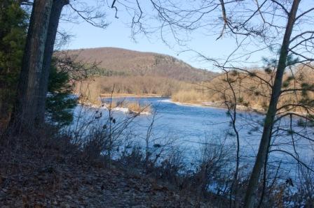
This shot depicts roughly where a PPL transmission line would cross the Delaware River if Route A is selected to avoid NPS land in the Delaware Water Gap area. At the far left would be the 3-lane and Cummins Hill, and on the far right, Montague, NJ. This option, in fact, would require a tower on an island in the river. (photo (c) Geoffrey Peckham)